The trek from Kyzyl-Suu to Jeti-Ögüz, crossing the Archa Tor mountain pass, was one of the most intense and solitary experiences I had in Kyrgyzstan. For three days I traversed isolated valleys, crossed numerous rivers (and I mean numerous), crossed a high pass at 3,900 meters, and explored remote areas where you practically never see another soul. It's a less traveled route than other more popular ones like Ala-Kul, but no less impressive for that.
What attracted me most to this trek was precisely that feeling of total isolation, of moving through landscapes where the human presence is minimal. While you don't cross any iconic lakes, the surroundings offer no respite. You'll see mountains, incredible panoramic views, meadows, and even rivers that you have to cross on horseback or in a rudimentary elevator.
An adventure for those seeking to get off the beaten track and connect with nature in a more intimate way.

This post may contains affiliate links. If you purchase through these links, I may earn a commission at no extra cost to you. Thank you for your support!
Table of Contents
🗺️ Archa-Tor Trekking Fact Sheet
| Start |
| Kyzyl-Suu |
| Final |
| Jeti-Oguz |
| Duration |
| 3 days |
| Distance |
| 58 km |
| Estimated time in hours |
| 23 hs |
| Max. Altitude |
| 3900m |
| Difficulty |
| Moderate |
| Signaling |
| None |
| Water/food |
| Water can be found in rivers and some food can be found if there is a yurt camp. |

Do you want to follow this route precisely?
Download the KML/KMZ file of the Archa-Tor Pass trek and open it in apps like Maps.me or Gaia GPS to view the complete route offline. Ideal if you want to navigate the valley with confidence, even without a signal.
Download the file on Gumroad for a symbolic contribution.

How to get to Kyzyl-Suu from Karakol
To get to Kyzyl-Suu from Karakol you have to go to the marshrutka station in Karakol (see location on the map), minibuses frequently leave towards Kyzyl-Suu throughout the day, especially in the morning and at midday. The journey takes about an hour, and the scenery along the route is very picturesque, skirting part of Lake Issyk-Kul and passing through small rural villages.
Marshrutkas usually leave once they are full, so there are no fixed times, but you don't need to book in advance. Just go to the station, ask for the minibus to Kyzyl-Suu, and wait a few minutes.
Once in Kyzyl-Suu, you can start walking from the village itself or arrange local transport (such as a taxi) to the start of the trail, depending on the exact route you will follow.
Save this post on Pinterest

Where to sleep during the trek from Kyzyl-Suu to Jeti-Ögüz
Unlike the Ala-Kul trek, where there is more infrastructure and yurt camps, on the route between Kyzyl-Suu and Jeti-Ögüz the sleeping options are much more limited, especially before crossing the Archa Tor pass. This trek can be done in three or four days, but whichever you choose, you'll likely need to be self-sufficient for at least one night.

First night
The first night I camped on a plateau before the pass (see location on the map), an incredibly beautiful place, surrounded by mountains and completely alone.
It was one of the most impressive points of the trek, but also one of the most emotionally challenging; the solitude, the wind, and the changing weather can command respect, especially if one is not used to camping in such isolated places.

Second night
On the second night, as you descend from the pass, you're more likely to encounter some human presence. There are some yurt camps during the summer, and you can also see the odd cabin or cottage.
I ended up sleeping in a local family's cabin, where they offered me hot food and a room to share with the children. No one spoke English, but the hospitality was incredible, and it turned out to be a very valuable cultural experience.

In short, this trek requires bringing a tent and some food as a precaution, but it also leaves room for unexpected encounters with local people.

🥾 Useful tips for trekking to the Archa-Tor Pass
It's a challenging but absolutely unforgettable trek, ideal for those seeking a solo adventure in the wild.
- Wear warm clothing in layers, even if the day starts out hot. At altitude, the weather changes quickly and it can get very cold, especially near the lake and at night.
- Unlike Ala-Kul, which wasn't essential, it's recommended to bring a wind- and rain-resistant tent on this trek. In addition to a good quality sleeping bag, with a comfort temperature of at least 0°C (better if it is -5°C or less) and a thermal insulating mattress or mat, to prevent heat loss from the ground.
- Bring trekking poles if you have them. They're a great help on steep climbs and descents. They're also a great way to help you navigate through rapids.
- Bring water, although there's no need to carry so much water from the start, as there are many rivers and waterfalls throughout the trek where you can refill your supplies. However, be careful: It's advisable to avoid areas where animals are nearby, as they could contaminate the water. For added safety, you can use water purification tablets or bottles with built-in filters, which allow you to drink directly from the stream more safely.
 Don't underestimate the altitude. The maximum altitude reached at the Archa-Tor mountain pass is approximately 3900m, so while it's not extreme, it's a good idea to acclimatize a bit if you're coming from lower altitudes.
 Waterproof hiking boots. There are steep sections with loose stones and many rivers or waterfalls to cross.
 Download offline maps or bring a GPS with the track of the route. This trail is much less marked than the Ala-Kul one, since the number of people who use it is much lower. I recommend using Maps.me with the downloaded map of the area. The app has marked the walking trails around the Tian Shan Mountains.

📅 When is the best time to go trekking?
The best time to trek from Kyzyl-Suu to Jeti-Ögüz is between June and September, when mountain passes like Archa Tor are snow-free and the weather is more stable. During these months, days are longer, visibility is better, and you're more likely to find active yurt camps in some valleys.

Outside this window, conditions can become complicated by snow, cold, or heavy rain, and many of the families living at altitude descend to the villages. It's always a good idea to check the weather before you leave, even in summer, as it can change quickly in the mountains.

Guide Map for Trekking from Kyzyl-Suu to Jeti-Oguz
How to get to the starting point of the trek
The trek from Kyzyl-Suu to Jeti-Ögüz can start directly from the village of Kyzyl-Suu, but many hikers choose to start from the hot spring resort called Dzhyly-Suu, located about 21 km further into the valley (see location on map). From there, the road ends and the most interesting part of the hike truly begins.
This first 21 km stretch is on a gravel road that could easily be avoided. Walking the entire route is not recommended unless you are planning to do the trek in 4 days, as it is long, dusty, and quiet.
From where the marshrutka drops you off in the village of Kyzyl-Suu, there are usually taxis or local cars that offer to take you to Dzhyly-Suu, although the price can be a little high if you go alone. Another option, which was the one I chose, is hitchhiking: of the 21 km, I walked about 10 in total and the rest I did in two vehicles. The first with a local who lived in a small town along the way, and the final stretch I did with a group of Russians who were on an excursion to the hot springs.

Once in Dzhyly-Suu the landscape changes completely and the real mountain adventure begins.
Day 1: From Kyzyl-Suu to Archa-Tor
| Distance |
| 32 km (21 to the hot springs + 11 to the camping site near the mountain pass) |
| Estimated time |
| 7-11 hs (depending on where we start) |
| Elevation Profile |
| From 1.800 mts to 3.400 mts |
The first day of the trek is marked by one important variable: how far you can advance on the 21-km stretch between the village of Kyzyl-Suu and the Dzhyly-Suu hot springs resort. This journey, which can be done on foot, by taxi, or hitchhiking, will determine whether you can reach the vicinity of the Archa-Tor pass in a single day, or if you need to spend the night before beginning the real climb.
In my case, I managed to cover approximately half of that stretch by car, thanks to two rides that picked me up along the way, which allowed me to reach my goal for the day, camping on a plateau near the Archa-Tor pass, in an isolated and spectacular place, ideal for spending the night before facing the climb the next day.
The road from Kyzyl-Suu to the hot springs is quite flat, with a slight very gradual incline, without steep slopes but with a landscape that becomes a bit monotonous. It crosses open countryside, passing through the occasional small village with sweeping views; it's a transitional stretch.

Once you reach the Dzhyly-Suu resort, the landscape changes radically. The pine forests appear, the river meandering near the trail, and, in the background, the first views of the steep mountains, tall and imposing, announcing that the real trekking is about to begin.

After a few hours of walking, you reach a very recognizable point on the trail: a weather station. It's an isolated structure, surrounded by mountains and grasslands, where the valley opens up.

Passing the weather station, the valley continues to open up, but soon comes a small surprise: you have to cross the river and there is no bridge. But what there is, is a kind of handmade elevator, a rudimentary structure of pulleys and rope assembled by the local people, which allows crossing suspended over the water.
On the other side there was a yurt, and it was some children who, amid laughter and gestures, indicated that I should cross through there.

The crossing isn't free, they charged me around 400 som just to cross, but it's part of the experience. This place is also an excellent spot to rest or even spend the night, as the family in the yurt might offer you accommodation (even if they don't speak English, there's always room for basic understanding).
After the river, the trail changes. A steeper climb begins, gaining altitude quickly. Vegetation thins out, and the landscape becomes more rugged, rocky, and exposed to the wind.

After that demanding climb, I reached a wide and lonely plateau, just before the Archa-Tor pass. It was there that I pitched my tent for the night, surrounded by complete silence, interrupted only by the strong wind. Sleeping there was as spectacular as it was intimidating, a memorable experience.
🏞️ Day 2: Crossing the Archa-Tor pass and descending into the valley
| Distance |
| 14 km |
| Estimated time |
| 6-8 hs |
| Elevation Profile |
| 3.400m – 3.900m – 2.500m |
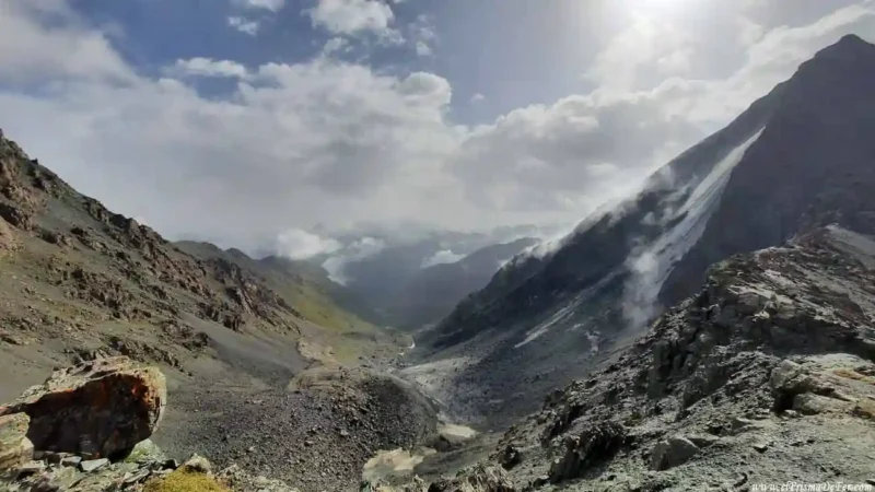
The main objective of the second day is to cross the Archa-Tor Pass, which reaches approximately 3,900 meters above sea level. This is a similar altitude to the Ala-Kul Pass, but with a completely different atmosphere.
From where I spent the night, the climb becomes noticeable quickly. As you gain altitude, the views of the Tian Shan Mountains become increasingly impressive.

While the Ala-Kul pass is best known for its spectacular turquoise lake, the Archa-Tor has a different kind of magic. Here there are no campsites, no hikers, and no well-marked trail. It's just you, the wind, and the Kyrgyz mountains. The vastness and solitude make the crossing feel far more epic.

Once past the highest point, the descent into a new valley begins, with views that at times recall the descent from Ala-Kul. The green landscape reappears, along with a river that meanders towards the valley floor.

Once the valley is reached, one of the most challenging sections of the day is reached: the crossing of a wide river and with a very strong current , without any bridge.
The only option is to look for a nearby yurt, as they only start appearing in this area, and ask for help to cross on horseback.
I had to negotiate with one of the few men I saw on the entire trek. He initially asked for 1,000 som, but we settled on 600 som, a rather high price for the brief service. But there's not much of an alternative; trying to wade across the river on foot can be dangerous due to the strong current.

After crossing the river, the day ended very differently than the previous one. This time, I found a cabin where a local family lived (see on the map) and asked them if I could stay for the night, paying of course (about 1,000 som).
Without speaking any English, but with good vibes, they offered me hot food and a corner to sleep in, which I shared with the children of the house.
After the previous night, camping alone at almost 3,900 meters in the cold and wind, that small shelter and the human warmth were a blessing.

Day 3: The final descent to Seven Bulls Rock
| Distance |
| 12 km |
| Estimated time |
| 4 hours |
| Elevation Profile |
| From 2.500m to 2.000m |
The third day is undoubtedly the least physically demanding, as the entire route is downhill. From the cabin where I spent the night, it was about 12 km to the end of the trek, first crossing a wooded area that followed the course of the river.
Unlike the previous days, here the landscape was more inhabited, with yurt camps and local presence who used those valleys as a grazing area. Even so, there still wasn't much foreign tourism to be seen.

As the hours passed, the forest opened up until it led to a wide clearing where the Seven Bulls Rock rises, a very striking reddish rock formation, which gives its name to the Jeti Oguz area.
It's a very scenic end, ideal for concluding the trek with a breathtaking view. There's even a nearby viewpoint that allows you to better appreciate the shape and color of these formations, similar to the colorful mountains seen when we began the trek from the Kyzyl Suu side.

After so many hours in nature and solitude, reaching this point feels like returning to civilization after a retreat.
How to get back from Jeti-Ögüz to Karakol
At the end of the trek, there is no need to go all the way to the main village of Jeti-Ögüz (which is much further down the valley). Most hikers finish their trek near the famous rock formations known as the Seven Bulls (Jety-Ögüz Rocks), which mark the most accessible point for transportation.
There are usually taxis or local drivers waiting there, as it is a tourist area. You can negotiate a transfer to the village of Jeti-Ögüz, which is a few kilometers further down, and although it can be done on foot, after several days of walking it is very likely that you will benefit from getting into a vehicle.
Marshrutkas depart for Karakol from the village of Jeti-Ögüz, although not as frequently as other routes, so you may have to wait a while or share a taxi with other travelers or locals. Alternatively, you can ask the same driver to take you directly to Karakol, if the price is reasonable.
Final thoughts on the trek
I also loved this trek, and although the landscape impressed me more with Ala-Kul, with its picture-postcard glacial lake and the beauty of Altyn Arashan, the path between Kyzyl Suu and Jeti Oguz offered me something very different, a much more introspective and solitary experience.
Here, adventure is palpable, with that adrenaline rush that comes from knowing there's no one around to help if something goes wrong. Crossing rivers without bridges, relying on your gear and your intuition, sleeping alone in the middle of nowhere… all of that gives the journey a different and more intense flavor.
It's not just a walk through beautiful landscapes, it's also an exercise in self-sufficiency and connection with the nature that surrounds us.
It was definitely one of the most authentic journeys I've taken in Kyrgyzstan, and one of those experiences that leaves a lasting impression on you, both for everything they demanded of you and for everything they gave you.
Video summary of the 3 days trekking through Archa-Tor
Frequently asked questions about trekking through the Archa Tor pass
Where is the Archa Tor pass located?
The Archa Tor Pass is located in the Issyk-Kul region, connecting the Kyzyl Suu Valley and Jeti-Oguz valleys in eastern Kyrgyzstan.
How many days are needed?
It is usually done in 3 or 4 days.
What difficulty does it have?
It is a trek of moderate to demanding difficulty, mainly due to the elevation gain to the pass, the altitude (more than 3,500 m), the lack of campsites to sleep in and the solitude of the path.
What is the best time to do it?
From June to September, when the pass is usually snow-free. Before or after this time, mountain experience may be required.
Where do you sleep?
You'll most likely have to sleep in a tent one night. The other nights you'll probably be able to find a yurt camp.
Is it signposted?
Not too much. While there is a marked trail, it can be confusing at times. It's recommended to bring a GPS with a downloaded track or use offline apps.
Is there water on the road?
Yes, there is plenty of meltwater and rivers, but it is always recommended to filter or purify it.
Support The Prism of Fer!
Your support helps me continue creating free content on the blog. Thank you so much!