When I visited El Chaltén, that small town lost in the heart of Patagonia, surrounded by majestic mountains, imposing glaciers and trails that seem straight out of a dream, I discovered that love at first sight does exist.
It's considered the national trekking capital, and with good reason: every corner invites you to lace up your hiking boots and go for a hike among landscapes that leave you breathless. And not just because of its imposing nature, but also because of the special energy in the air, the hikers who come from all over the world, and that feeling of literally being at the end of the world.
Once you see Fitz Roy peeking out from the clouds, you understand why so many consider this corner of southern Patagonia one of the most magical in Argentina.
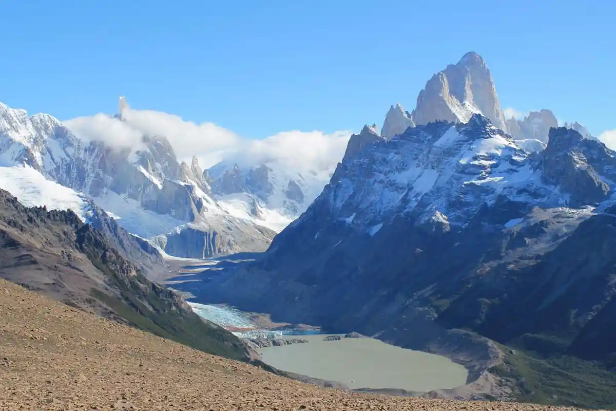

Table of Contents
Where is El Chaltén located?
El Chaltén is located in the southwest of the province of Santa Cruz, within the Los Glaciares National Park, in the heart of Argentine Patagonia. It is about 215 km from El Calafate and very close to the border with Chile.

The town is nestled in a valley surrounded by mountains, right where the De las Vueltas and Fitz Roy rivers meet, giving it a stunning natural setting.
Its location is perfect for hiking and nature lovers: the main treks to Mount Fitz Roy, Laguna de los Tres, Laguna Capri, Laguna Torre and other emblematic landscapes of southern Argentina depart from the town itself.

❤️ Why El Chaltén is my favorite place in Argentina
Of all the places I visited in Argentina, El Chaltén has something that makes it unique. Perhaps it's that feeling of absolute freedom, of being able to walk for hours among valleys, lakes, forests, and epic mountains with nothing but the Patagonian wind and the sound of your footsteps for company.

It's a place where every trail offers a new view and every sunrise invites you to go out again, no matter how tired you were from the previous day.
I've been to El Chaltén twice, and each visit leaves me wanting to return. And I'm sure I will, again and again, because few places in the world manage to convey that blend of peace, excitement, and connection with nature like this corner of Patagonia.
How to get to El Chaltén
The town doesn't have its own airport, so the most common way is to fly to El Calafate, which is about 215 kilometers away. From there, daily buses depart along a stunning scenic route, bordering Lake Argentino and crossing the Patagonian steppe into the heart of the Andes.
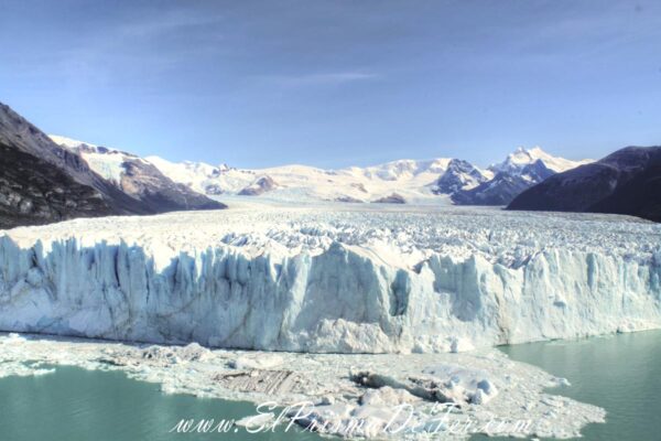
If you want to know more about one of Argentina's natural wonders, you can read the post I wrote about the Perito Moreno Glacier
The journey takes around 3 hours, and if the weather is good, the views of Fitz Roy on the final stretch are unforgettable.

Another alternative, more for those who travel at their own pace, is to rent a car or hitchhike (very common among travelers), which allows you to stop at viewpoints and enjoy the scenery without rushing.
During high season, there are also direct buses from Bariloche or Perito Moreno, although they are long journeys.
Some curiosities
Origin of the word “Chaltén”
It is interesting to know the origin of the name. The native peoples of these lands, the Tehuelches, they believed that the mountain with outstanding peaks, what we know today as Mount Fitz Roy (3,405 meters), was a volcano.

They thought the constant plume of smoke rising from its peaks was the vapors of a volcano. This confusion led them to call the mountain "Smoky Mountain," or rather, Chaltén
The rational explanation for this effect is that the spaces between the peaks act as an "air slide" for passing clouds, creating a visual effect similar to the trails of a volcano.
The Huemul, a mammal native to Argentina
One of Argentina's native animals, The Huemul, lives in this area. A mammal from the deer family that is sadly in danger of extinction. Park rangers tell us what to watch out for if we see one, not for ourselves, but for them.
They are said to be very skittish animals, and if threatened they can launch some kind of attack that could ultimately end their lives.
If you encounter one, consider yourself lucky and please take care of them. I haven't been lucky enough to see them in the wild on any of my visits yet.
Origin of the town for defensive reasons
The town of El Chaltén is relatively young. It was founded in 1985 when Argentina and Chile were engaged in territorial disputes. The ownership of these lands, along with several other lands in Patagonia, was constantly disputed between the two countries. Indeed, they were on the verge of going to war to determine ownership of these lands.

As a precautionary and intimidatory measure, the Argentine government founded the town to establish a strategic and military base to confront and ward off a potential confrontation.
Fortunately, everything ended democratically between the two countries, and to this day, the town continues to grow primarily for tourism purposes.
If you want to know more about unique destinations in Argentina, be sure to read the articles I wrote about how to visit El Valle de la Luna in San Juan and the Sierra de las Quijadas National Park in San Luis.
Where to stay in El Chaltén
Being a small town, it doesn't really matter where you stay. Anywhere will be fine. Based on my experience, I can recommend two places:
Hostel Condor de los Andes
It's a typical backpacker hostel, with a shared kitchen, breakfast included, and both private and shared rooms. It's a great place to meet other travelers and share tips and experiences.
The positive aspects are the price and the location near the bus terminal. The negative aspects are that the kitchen is too small for so many travelers, and the breakfast could have been more comprehensive.
Departamento Latitud 49
They're a few blocks away from the bus terminal, but still within walking distance. They're much more comfortable apartments, with their own kitchen and greater privacy, but the price is slightly higher than the hostel.
Precios para visitar el Chalten (actualizado 2026)
If there was one thing that stood out every time I recommended someone to come to this place, besides the scenery, of course, it was that it was absolutely free to come and hike the different trails. I always thought it was a plus to be able to come and hike every day at no cost.
This is no longer the case. Now, the entrance fee to Los Glaciares National Park on the Chalten side is the same as the entrance fee on the Calafate side to see the Perito Moreno Glacier. It costs $ 15,000 Argentine pesos for nationals and $ 45,000 Argentine pesos for foreigners. I understand this price is for each day we trek in the area (as a colleague told me). Be careful, because this can significantly increase the cost of our stay.
You can check the updated price from the official website of National Parks.
Trekking in El Chaltén
Not in vain El Chaltén is called the national capital of trekkingBecause in addition to enjoying incredible landscapes, we have a good number of hiking trails to explore, all on our own.
And this is what amazes me. We can spend days and days walking the trails in the area, without any guide or excursion, just us walking for hours and enjoying the surroundings and the different landscapes.
Every trail you choose will lead to unique and unforgettable views. Valleys, mountains, lakes, forests—each path is a Pandora's box waiting to be discovered.
Let me tell you a little about it.

Trail of the Laguna de los Tres
This is one of the two classic circuits in El Chaltén. The total distance is approximately 25 km round trip, taking approximately 8 hours depending on your fitness level.
The trail begins at the end of San Martín Avenue, where the town ends and the parking area is located. During the first hour of the hike, the slope is somewhat steep, and you will reach a viewpoint of the Valley of the River of the Turns.

These first views already blew my mind. They made me feel like I was in Tolkien's Middle-earth. We're facing a wide, expansive valley at our sides. It's hard not to stop and take mental photos.
In a few more minutes of walking, you enter the Del Salto stream valley towards Mount Fitz Roy and approximately an hour and a half into the journey you will reach a well-signposted natural rocky viewpoint.

The path continues always up the Del Salto stream to the drainage area of the Mother and Daughter lagoons.

About 4 hours after leaving El Chaltén you first arrive at Poincenot Base Camp (one of the busiest camping sites in the National Park) and after crossing the Blanco River, to the Río Blanco base camp (for climbers only).
From here the path continues with a somewhat steep slope of approximately 400 meters of elevation gain to the Laguna de los Tres, which will require a little over an hour of effort.
At this point, when I went the second time with my girlfriend, she had a couple of meltdowns. She was dizzy, cold, and very tired. I had to convince her a couple of times that we were almost there (I'd been telling her this for an hour :D) and that the reward of arriving was worth the last bit of effort.
The trail ends at a huge arch-shaped formation containing the lagoon, formed by the action of glacial advance and subsequent retreat, with an extraordinary view of the lagoon and De los Tres glacier.

It's usually very windy and cold in this part, but the views are unique. This spot is the closest we'll get to the granite face of Mount Fitz Roy and its surrounding peaks.

After that, we just have to go back the way we came, although this time we're going downhill, which is faster.
Cerro Torre Trail
This is another of the two classic Chaltén circuits. It's a little less intense than the previous trail. And while the total distance is about 15 km round trip, taking 6 to 7 hours depending on your fitness, it's not as steep as the Laguna de los Tres Trail.

The road enters the Fitz Roy River Valley and continues up the course of this river to its source. Just 15 minutes into the hike, you reach your first viewpoint located in a gorge of the Fitz Roy River, which offers a panoramic view of the Torre Hills and Mount Fitz RoyOn the other side of the river is the Margarita waterfall.

Halfway through the journey we reached a natural viewpoint with an incomparable panoramic view of the Adela mountain range and Torre hill and the granite needles that accompany it.

The road finally crosses the De Agostini base camp where it is possible to spend the night.
Leaving base camp behind, the trail heads toward a mound, which can be climbed in about 15 minutes.

From there it is possible to go down to the lagoon, or continue along the same edge for another 2 km. to the Maestri lookoutThis lagoon usually groups numerous icebergs on its shore that break off from the front of the Grande Glacier.

The hills are always viewed from the west, so they are directly illuminated by the sun only in the morning. You'll get the best photographs at sunrise, when the granite turns reddish just as the sunlight reaches them for the first time of the day.
Mother and Daughter Lagoons Trail

The Cerro Torre and Laguna de los Tres trails can be linked via the Madre e Hija trail, which is 8 km long and has a 200-meter elevation gain and can be covered in approximately 2 hours and 30 minutes.

This is a trail where you can see two lagoons, the larger one called "Madre" (Mother) and the smaller one called "Hija" (Daughter). Allow time from the village to the trailheads: 7 km on the Fitz Roy trail and 5.5 km on the Torre trail.

Tumbado Fold Hill Trail
In my opinion, one of the most intense trails, along with the Laguna de los Tres, but with the best views to enjoy.
The trail begins at the National Parks square just at the entrance to the town. There is a small gate that indicates two paths: to the left are the trails to the Los Cóndores and Las Águilas viewpoints, and to the right the Tumbado Fold and Toro Lagoon / Wind Pass.

This trail maintains a constantly ascending slope of approximately 1,100 meters in total, until reaching the viewpoint located about 1,500 meters above sea level.
After an hour of starting the trail, the path crosses a plain called Pampa of the Carts, from where you can appreciate the Huemul Hill, Lake Viedma to the south and the imposing Andes mountain range to the northwest, highlighting Cerro Torre and Mount Fitz Roy.
The trail then enters a beautiful forest until reaching an altitude of approximately 1,000 meters above sea level, where the landscape changes abruptly.
I felt something really strange the first time I walked through this forest. I was completely alone (my cousin had to return to Buenos Aires earlier), and I felt a strange sensation around me. It was as if the trees were somehow communicating with me.
Yes, I know what you're thinking, and I can assure you I hadn't ingested any psychedelic substances. But standing there, completely alone with the wind rustling the leaves, it was as if we had entered into a kind of communion together.
Imagine the affection I had for them, that before leaving I hugged a tree to say goodbye (that's why I say this place touched my heart).
Um... well, let's continue. Once we pass through the forest, the trees give way to bushes and scrubby vegetation, and perhaps among the numerous stones along the path, it's possible to find marine fossils dating back 100 million years.

The last part of the path, with typical high mountain stones, continues marked with yellow bars until reaching the Mirador del Pliegue Tumbado.
And here we are going to witness the BEST LANDSCAPES IN THE WORLD. Well, I got excited, but they are truly incredible. It's as if we were in a natural amphitheater, and the setting is the Andes mountain range, with Mount Fitz Roy and Cerro Torre as the protagonists.

The views from this spot are unparalleled. I can assure you I've never seen such a spectacle in my life. I don't even know what words to use to describe the sensations that passed through me at that moment.

If we want to climb to the top of Pliegue Tumbado, it will take us another hour of walking, ascending another 280 meters from the viewpoint with a somewhat steep slope.

The summit offers an extraordinary 360-degree panoramic view.

The second time I climbed this viewpoint was a completely different experience. This time I witnessed something equally wonderful, all the emotional changes my girlfriend went through along the way, haha.
I remember going through all the stages. It began with joy and enthusiasm, giving way to a state of overwhelm and suffocation within the same forest that had enchanted me in previous years. Then came the despair of never seeing the summit again, until it finally ended with a feeling of self-realization and enormous satisfaction at having been able to reach it and witness such views firsthand.

Although you may be exhausted from so much effort at the moment, over time you'll surely forget the hardship and remember the positive aspects of the experience.
Now I'm eager to see how I'll experience the third time I return along this path.
Condor Viewpoint Trail
It's one of the most accessible trails due to its short distance and low elevation gain. It's also an ideal option if you're just visiting El Chaltén for the day or if you want a break from more intense hikes.
The landscape includes the Torre and Fitz Roy mountain ranges, as well as a panoramic view of El Chalten and the Río de las Vueltas Valley. This hike is ideal for those unfamiliar with mountain hiking.
With a bit of luck, you can admire the condors in flight from this 40-minute viewing point, 1 km long and with a 100-meter elevation gain.
Eagles Viewpoint Trail
Like the Sendero de los Condores, this trail is ideal for those spending the day in El Chaltén or for those who want to rest their legs from other treks.
It begins at a fork in the trail from the Cóndores viewpoint. It's another 20-minute hike to appreciate the Patagonian steppe, part of Lake Viedma, and Route 23, which provides access to the area.

Chorrillo del Salto Trail
Another perfect trail to do in half a day and rest your legs.
The trail begins in El Chaltén, at the end of Av. San Martín, at the trailhead to Laguna De los Tres, but this time you must take the path that heads to the right.
He Chorrillo del Salto It's a 20-meter-high waterfall where you can enjoy the water and take a walk through the forest. You can access it by car via Route 41, up to the parking lot, and from there, it's just a 10-minute walk.
The waterfall is located right on the last stretch of the Arroyo del Salto, before it flows into the De las Vueltas River. This hike is less than 4 km from El Chaltén.
El Pilar Trail (easier alternative to reach Laguna de los Tres)
This trail is a more accessible alternative to reach the Poincenot Camp and Laguna de los Tres.
To reach the trailhead, head to kilometer 17 of Route 41 from El Chaltén. There are excursions to Laguna del Desierto that take you to this trail for a fee. Although it begins on private property, there is no entrance fee and there is a parking lot.
At 1:20 hours after starting this trail we can find a natural viewpoint at Piedras Blancas Glacier, and then if we advance another 40 minutes, the path joins the Laguna de los Tres trail at the Poincenot camp.

This is an interesting alternative to reach the lagoon because there's less of an uphill climb. You can then descend along the main trail toward the village and enjoy the views of the valley that you missed on the way there.
Desert Lake and Huemul Glacier
This beautiful lake is located at the end of the De las Vueltas River valley. It's 37 km from El Chaltén, and to get there, if you don't have your own vehicle, you can hire any of the private transfer services in town.
My cousin and I had the fantastic idea of renting some bikes and riding all the way to the lake.
In the village we had been told that some people often do this, especially a man nicknamed “the Apache,” who had the habit of riding his bicycle back and forth.
We think “…and well, if the Apache can do it, why can’t we?”…how naive.
If we had known that the 37 km route to the lake was gravel, with climbs, descents, and above all, a headwind, I'm sure I wouldn't even be telling you about this.
We pedaled and pedaled for hours, stopping every 15 minutes, as the wind was relentless. It was too demanding on our already tired legs.

The reality was that we had a lot of trouble making this crossing. The positive thing is that once we pass through the De las Vueltas River valley, a route begins through forests that is less windy and more accessible for walking.

We finally arrived, exhausted, but we arrived. We must have noticed that the people strolling by the lake were congratulating us. They had seen us from their cars, and they all agreed on how difficult that experience must have been.

Desert Lake doesn't live up to its name. It's a paradise of forests, turquoise water, hills, glaciers, and waterfalls where, if you're energetic, you can enjoy hikes and excursions of varying lengths and difficulty.

To get to Lago del Desierto without your own car or bicycle, you have no choice but to hire a private transfer.
Trail to the Huemul Glacier
This is the most popular hike for those arriving at the lake and short on time, as it offers extraordinary views of the north face of Cerro Chaltén and the De las Vueltas River valley.
I know my cousin and I were physically exhausted, but we couldn't resist climbing this trail. We were told it was intense but short, so we decided to give it a go.
From the free parking area at Punta Sur, head to the nearby parking lot where the trailhead is located. You must pay the entry fee, as the entire trail is on private property.
The trail quickly enters a lenga forest and begins its ascent a few minutes later along a well-marked path. After just over half an hour of climbing, you reach a ridge with panoramic views of the De las Vueltas River valley and Mount Fitz Roy.
To the northwest you can see Desert Lake and behind it the Forest Range.
If we continue along the ledge for about 15 more minutes we will reach the beautiful Huemul lagoon, fed by the glacier of the same name.

There are also beautiful landscapes to enjoy from up here. Everything around is very green, and we'll get views of El Chaltén from other perspectives.

Return to Chaltén
Finally, late in the afternoon, we had to return, but it was impossible to do so by bike again. We were already at our wits' end.
Luckily, a man who worked there offered to take us back to town in his truck. It wasn't cheap, but it was the only way we could get back in one piece.
So, what had taken us hours, sweat, and tears on the way there took us less than an hour on the way back. On the way back, the driver waved to a smiling young man riding his bicycle.
Who was he? we asked out of curiosity. The “Apache.”
Organized activities in El Chalten from Calafate
How to climb Cerro Chaltén
The mountain is 3,375 meters high, but very difficult to climb. It is chosen annually by mountaineers from around the world for high-level professional expeditions. It is not possible to climb on foot, only with ropes and climbing equipment.
The National Parks office is the one that must authorize this activity.
What is the best time to travel to El Chaltén?
Without a doubt, the best months to travel to El Chaltén are spring and summer, from September to March or April, when the weather conditions are most favorable.
The days have more hours of sunlight and the vegetation is at its peak.
During the other months, it's also possible to go, but be careful because the intense cold can cause snowfall that can close some of the trails.
Tourism has declined significantly, and many townspeople take advantage of this time to spend the winter in other cities, such as El Calafate.
Final sensations
As a lover of trekking in natural environments and mountainous landscapes, this little corner of the world resonated with me both spiritually and physically. It turned out to be a true paradise for me.
If you enjoy hiking and are in good physical condition, you can easily dedicate four or five days to this activity. There's nothing better than visiting the Perito Moreno Glacier in El Calafate, and then spending a few days in this magical town.
Keep in mind that the trails to Cerro Torre, Laguna de los Tres, and the one leading to the Loma del Pliegue Tumbado viewpoint are the longest and most demanding, taking a day each. That's three days.
Another day could be the short hikes to Salto del Chorrillo and the ones to the Águila and Cóndores viewpoints. And if you have more days, you could dedicate them to Lago del Desierto and its surroundings.
Regardless of how many days you decide to stay, try to hike at least the trails to Loma del Pliegue Tumbado and Laguna de los Tres. In my opinion, these are the ones with the best views of the entire valley, Cerro Torre, and Mount Fitz Roy. You won't tire of taking mental pictures of all the postcards around us.
Support The Prism of Fer!
Your support helps me continue creating free content on the blog. Thank you so much!