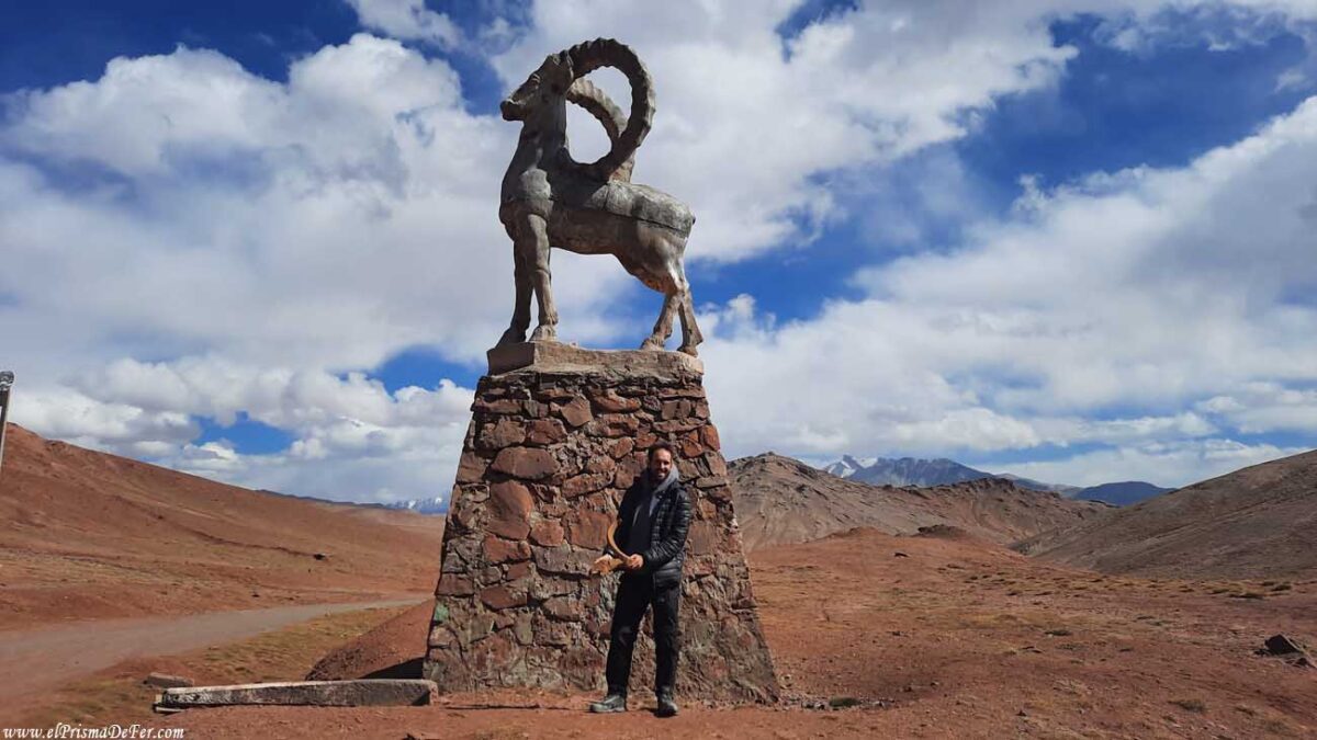
Trekking in the Fann Mountains was one of the experiences that most marked me during my time in Tajikistan. I decided to take the hike from the Artuch Alplager Hotel to the Alauddin Pass, crossing the incredible Kulikalon Lake, in the heart of the mountains. A route that combines the best of the Tajik landscape: turquoise lakes, snow-capped peaks, lonely trails, and overwhelming nature.
While Tajikistan is famous for the Pamir Highway, for me this stretch in the Fann Mountains was just as impressive, and even more accessible in terms of logistics and physical effort. I experienced it as a short but very complete trek, ideal for those looking to walk independently through valleys and mountains while still feeling that sense of isolation, vastness, and beauty that so perfectly defines this country. Kulikalon and its surroundings became, without a doubt, one of my favorite places of the entire trip.
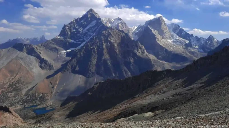

Table of Contents
🗺️ Technical information for Trekking in the Fann Mountains: Artuch – Alauddin Pass
| Start |
| Hotel Artuch Alplager |
| Final |
| Alauddin Pass – Hotel Artuch Alplager |
| Duration |
| 1 day |
| Distance |
| 24 km |
| Estimated time in hours |
| 12-14 hs |
| Max. Altitude |
| 3800m |
| Difficulty |
| Moderate (by km) |
| Signaling |
| None, but well-marked trails |
| Water/food |
| None |

Do you want to follow this route precisely?
Download the KML/KMZ file of the Alauddin Pass trek, starting from Artuch Alplager and crossing Lake Kulikalon, and open it in apps like Maps.me or Gaia GPS to view the complete route offline. This is ideal if you want to navigate the valley with confidence, even without a signal.
Download the route to Alauddin Pass on Gumroad for a small contribution.
🚐 How to get to Hotel Artuch Alplager from Panjakent
The starting point for this trek in the Fann Mountains is the Hotel Artuch Alplager, located about 70 km southeast of Panjakent. Although the distance does not seem far, access is not so direct and can take several hours, especially in the last section, which is gravel and mountainous.
From Panjakent you have two main options:
🚕 Private taxi
The most practical (but also most expensive) way is to hire a private taxi to the hostel. The journey takes between 2.5 and 3.5 hours, depending on the road conditions.
- Estimated price: between 250 and 350 somoni (approximately 20–30 USD), although it may vary depending on the season and your bargaining skills.
🚗 Shared taxi + extra ride
Another cheaper option, but with an extra step, is:
- Take a shared taxi from Panjakent to Artuch village (see location on the map and ask about vehicles passing through that area).
- From there, arrange for someone to take you the last 7-8 kilometers to the hostel, either by negotiating with the same taxi that brought you to the village, with a local, or by hitchhiking. This part of the trail is more isolated and mostly uphill, so it may take some time.
📌 Advice: Si te alojás en Panjakent, algunos hostels pueden ayudarte a coordinar el transporte al Artuch Alplager, o incluso armar grupos para compartir costos con otros viajeros.

🏙️ Panjakent: Useful, but not very charming, waypoint
Panjakent wasn't a city I particularly liked. It has a somewhat chaotic and uncharming center, and beyond a couple of monuments and markets, it doesn't offer many tourist attractions. However, its location makes it a very useful strategic point: from here you can organize your visit to the Fann Mountains, go to the Artuch area and Lake Kulikalon, trek to the 7 lakes, or cross the border into Uzbekistan if you are coming from or going to Samarkand.
In that sense, Panjakent serves its purpose as a base of operations or a stopover, with some affordable accommodations and basic services to stock up on before continuing on your journey.
I stayed at Salom Hostel and I truly recommend it for its good vibes, facilities, and the friendly owners. It's common to meet other travelers who want to trek to the Fann Mountains or even people going to or from Uzbekistan. It's an ideal place to get organized and, hopefully, get together with others to reduce transportation costs.
🥾 Useful tips for trekking in the Fann Mountains
Trekking in the Fann Mountains is a spectacular experience, and the great thing is that you can do it on your own without a guide, as long as you have some previous mountain experience and are comfortable with maps or offline navigation apps like Maps.me or Gaia.
 One advantage is that you can tailor the hike to how you feel: from short excursions around Kulikalon to multi-day treks connecting lakes and mountain passes. Even if you feel that a section is too challenging, you can always return along the same path or take alternative routes that are less difficult.
 Based at the Hotel Artuch Alplager, you don't need to bring a tent or cooking equipment, as the place offers simple but comfortable rooms, and you can also have your meals prepared, which makes logistics much easier.
 The maximum altitude I reached was approximately 3800 masl at the Alauddin Pass, so while it's not extreme, it's a good idea to acclimatize a bit if you're coming from lower areas.
 The paths are marked and traveled by other travelers in season, and there are several possible routes, depending on how much time and energy you have.
 I highly recommend using Maps.me with the downloaded map of the area. The app has marked walking trails around the Fann Mountains. You can mark your route beforehand or record the track as you walk.
📅 When is the best time to trek in the Fann Mountains?
The best time to visit the Fann Mountains is from late June to mid-September, when weather conditions are most stable, the mountain passes are clear, and the lakes reach their most intense colors.
- June: The landscape is beginning to awaken, with snow still melting at altitude. It's a good time if you want to avoid crowds, but some passes may still be snow-covered.
 July and August: These are the ideal months. The days are long and sunny, the temperatures are pleasant (although cool at night), and all roads are accessible.
 September: Still a good option, especially in the first half. The weather starts to get cooler and there are fewer people, but the autumn colors give the landscape a special charm.
 Off-season (October to May), many trails become inaccessible due to snow, the Hotel Artuch may close, and the weather is generally not conducive to safe trekking.

🏞️ Another popular option: the 7 Lakes trek
In addition to the Kulikalon and Alaudin Pass treks, the Seven Lakes (also known as Haft Kul) route is also very popular in the Panjakent region. This is a shorter and more accessible route, ideal for those who want to explore the beauty of the Fann Mountains without having to hike at high altitudes.
This trek can even be done in a single day if you have a vehicle, as there is a gravel road that runs along the seven lakes, one after the other, each with its own shade of blue or green, surrounded by small villages and mountains. It is also possible to do it on foot, in two or three days, sleeping in local homes or camping.
It's an excellent option for those short on time or who prefer easier hikes. In my case, I opted for the trek from the Artuch Hotel to the Alauddin Pass, passing through Kulikalon Lake, which is more mountainous and challenging. I'll describe that trek in detail in this post.

Organized activities in the Fann Mountains
Guide Map for Trekking in the Fann Mountains
Day 1: Short trek to Chukurak and Kuli Lakes
| Distance |
| 6 km round trip |
| Estimated time |
| 3-4 hs. |
| Elevation Profile |
| From 2.200 mts to 2.800 mts |
The same day I arrived at the Artuch Hotel, I decided to do a short trek to the Chukurak and Kuli lakes. It's an easy walk that can be completed in a couple of hours round trip and isn't particularly physically demanding. It's not an epic route with stunning landscapes like others in the region, but it is a nice introduction to the mountain environment, ideal for starting to connect with the tranquility of the place and stretching your legs after the trip.

Depending on the time of year you go, the lakes can look very different: for example, when I went in September, Kuli Glacial Lake was dry, which took away some of the drama from the landscape. Still, it was a good way to get started and acclimatize for the days ahead.
Day 2: Trekking from Hotel Artuch – Alauddin Pass – Hotel Artuch
| Distance |
| 24 km round trip |
| Estimated time |
| 12-14 hs |
| Elevation Profile |
| From 2.200 mts to 3.800 mts |
Section 1: From Hotel Artuch to Lake Kulikalon
On the second day I started early, intending to reach Alauddin Pass, one of the highest points of the route.
The hike begins along a well-marked path that runs along the river, and soon passes by some local shepherds' houses, where it's common to see cows, donkeys, and goats roaming about. The slope is gentle, and you advance gradually between trees and small clearings.

After a while, you cross a kind of natural dam formed by an ancient rock collapse that blocked the passage of water and created a slope.

Once past that point, the trail suddenly opens up and the Kulikalon Valley appears, an incredible postcard with several lakes of different shades of turquoise, surrounded by snow-capped peaks.

Kulikalon Lake is the largest and most prominent lake in the landscape, but there are also smaller lakes that complete the scene. It's an ideal place to rest, take photos, and simply linger for a while, admiring the surroundings.

Section 2: Walking through the Kulikalon Valley
After arriving at Kulikalon Lake and taking a break, I experienced one of those mountain moments. While resting on the shore, I met some farmers tending their goats in the area. They didn't speak a word of English, but they still offered me food and a genuine smile, and I spent some time with them sharing that simple but unforgettable little moment.

I then continued walking peacefully through the valley, skirting the various lakes that dot the landscape: each with a distinct color and shape, reflecting the mountains in its still waters. What I loved most was the unique combination of alpine vegetation, crystal-clear waters, and the rugged peaks that rise like rock walls in all directions. Without exaggeration, it was one of the most paradisiacal places I visited on my entire trip through Central Asia.

The Kulikalon Valley has something special about it. Not only for its natural beauty, but also for that feeling of being completely immersed in the mountains, far from everything, without people, surrounded by a peace that's hard to put into words.

Section 3: The final climb to the Alauddin Pass (3800 m)
The third section begins in the Kulikalon Valley, and is probably the most demanding of the entire route: the climb to the Alauddin Pass, at an altitude of around 3,800 metres. Many hikers choose not to do this, as the elevation gain is considerable (an extra 1,000 meters) and the entire outward and return section can be long and arduous, especially if you are not used to hiking at altitude.

The trail begins gently winding up the mountainside, but soon begins to steepen, with steep, rocky sections that demand patience and steady legs. Halfway along, I came across a local family tending their animals, and as at other points on the trek, it was another reminder that this area is not only a paradise for travelers, but also a territory of traditional life.

Finally, after a few hours of climbing, I reached the Alauddin Pass, and what I saw left me speechless. One of the best mountain views I've ever seen: far below, the Alauddin Lakes sparkled like gems among the rocks, while all around, an amphitheater of snow-capped peaks and vertical walls framed the horizon. Tiredness disappears instantly when you find yourself facing such a picture-perfect landscape.

While resting at the Alauddin Pass, I came across some hikers coming from the other side, coming from the Alaudin Lakes area. They were doing the trek as a longer circuit, camping at different points and crossing from valley to valley. It is entirely possible to hike the area over several days, connecting Kulikalon, Alauddin, and other lakes, as long as you have camping gear and supplies. This option is ideal for those looking for a more complete adventure, with nights under the stars and daily hikes among some of Tajikistan's most spectacular landscapes.

The return to the Hotel Artuch
After resting for a while at Alauddin Pass, it was time to start the return journey. I descended with a mixture of satisfaction and amazement, knowing that I had managed to ascend from the 2,200 meters of the hotel to the 3,800 meters of the pass, crossing some of the most impressive landscapes I had seen in Central Asia.

The descent was more physically bearable, but I enjoyed it with a renewed energy. I had time, my body was tired but happy, and I allowed myself to walk peacefully through the Kulikalon Valley, passing by the lakes again, now with a different, warmer light, and an even deeper silence than in the morning.

I continued walking leisurely, almost meditating on each step, until nightfall surprised me, already close to the hotel, with the starry sky appearing between the silhouettes of the mountains. It was the perfect ending to a long, intense day, one that will stay with you forever.
🚗 How to get back to Panjakent from Hotel Artuch
To return to Panjakent from the Artuch Hotel, there are two main options. The most convenient is to arrange a private taxi, which the hotel can arrange or you can schedule a local contact in advance. This option is faster, but also more expensive.
Another option is to walk down to the village of Artuch (about 7-8 km) and, from there, try to take a shared taxi to Panjakent. I opted for this second option, leaving the hotel early to arrive in the village around 10 a.m.
It turned out the shared taxi didn't leave until 1 p.m., and when the newly arrived driver saw me, he invited me to his home to share a meal with his family while we waited. Although I didn't speak English, the Tajik hospitality was evident and sincere, and that unexpected pause became an anecdote I will remember forever.

Personal reflections on trekking in the Fann Mountains
I arrived at the Fann Mountains a little tired from so much mountain hiking and intense trekking. I had just spent almost a month in Kyrgyzstan, doing a lot of trekking and then crossing the Pamirs on my own, so my mind was already asking for a change, something different. I was really looking forward to getting to Uzbekistan and wasn't too keen on the idea of doing another trek in Tajikistan.
Honestly, I almost wouldn't have gone to the Fann Mountains if it weren't for the fact that several travelers highly recommended them. Without much expectation, I accepted the invitation, and today I can say it was one of the best decisions of the trip.

The Kulikalon region surprised me deeply: one of the most beautiful areas I've seen in all of Central Asia. Uncrowded, with completely natural lakes and a spectacular mountain landscape that invites you to stay longer and explore further.
In conclusion, the Kulikalon and Alauddin Pass trek not only exceeded my expectations, but ended up being one of the most beautiful areas of Tajikistan, and I definitely highly recommend it!
Video of trekking in the Fann Mountains
Support The Prism of Fer!
Your support helps me continue creating free content on the blog. Thank you so much!